
Spring is the best time to see the majestic waterfalls of the Northwest Corner in all of their glory. Along with a few familiar falls, we highlight Sages Ravine and present a lovely piece of music that was inspired by its haunting beauty.
Living in the Litchfield Hills comes with an abundance of outdoor pleasures and a gratitude for all the land has to offer. Hidden among the hills are magnificent falling waters of great depth and beauty. We came across three people who captured this beauty, each in their own way.
Russell Dunn is a licensed hiking guide and author of numerous hiking, kayaking, and waterfall guide books. He writes of our waterfalls with eloquence, wisdom, and thoroughness. Christy Butler is a professional photographer who has spent a great deal of time photographing waterfalls. His images are beautifully composed and exquisitely capture the gushing waters suspended in time. Together, these two creative outdoorsmen produced a book called Connecticut Waterfalls, A Guide, a truly extraordinary accomplishment and definitely a book worth having. Rick Sowash is also a hiker—and a biker, writer, author, and musical composer, who was inspired to create music for Sages Ravine while hiking the Appalachian Trail.
With this article, we have brought together a few excerpts and photographs from Russell and Christy’s book, along with a recording of Rick’s original music. We encourage you to pick up a copy of their book for a complete guide to all of the great waterfalls in our area and in the state. And we invite you to listen to the musical composition, here on our site, and then check out other works created by Rick Sowash. These three men have taken their passion and creativity to produce quality works for our enjoyment.
We start with Sages Ravine—the highlight of this article—and end with links to the music and the score.
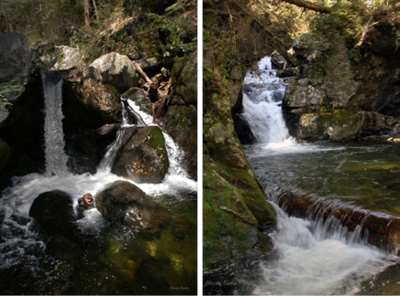
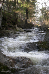
Falls at Sages Ravine
Location: Joyceville, Sages Ravine
Estimated GPS: 42º03.00’N; 73º25.57’W
Views: Lateral and head-on
Aesthetics: Excellent
Characteristics: Scenic; wild; multiple cascades
Accessibility: First fall–0.3-mile hike; second fall—0.35-mile hike/scramble; third fall–0.4-mile hike/scramble
Degree of Difficulty: To first fall–Moderately difficult; to second fall—Difficult; to third fall–Very difficult
Description: Multiple waterfalls have formed in a spectacular gorge called Sages Ravine. Covering a distance of over 1.0 mile, Sages Ravine Brook drops nearly 700 feet through a tortuous, chiseled defile, plunging over a series of large waterfalls and hidden pools, all encased in a forest of hemlocks. It is a very primordial area.
The first waterfall, near the bottom of the ravine, is 10 feet high, and part of a grouping of several cascades.
The second fall is an 8-foot-high, multi-step fall that drops into a shallow pool.
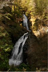
The third waterfall, called Twin Falls, consists of a 35-foot-high cascade which drops into a pothole-formed pool, immediately followed by a 25-foot-high, diagonally-inclined cascade.
A number of smaller waterfalls are interspersed between the main ones as well as further upstream.
There are also cascades on Sages Ravine Brook downstream from the ravine. Directly below the Rte. 41 Bridge spanning Sage Ravine Brook is a 15-foot-high cascade where the ruins of an old mill or bridge abutment wall are evident along its north bank.
History: Sages Ravine is named after the Sage family who were heavily involved in the area during the nineteenth century. Simeon Sage founded the Sage Iron Company, and the area quickly became known as Sage’s Forge, only to change to Joyce’s Forge when it was purchased later by John D. Joyce.
The most prominent member of the Sage family was Zachias (also spelled Zaccheus) Sage, a Revolutionary War solider who is interred in the nearby Candee-Sage’s Cemetery.
Henry Ward Beecher was so impressed by the ravine, particularly Twin Falls, that he publicized the natural wonder in his “State Papers” during the 1850s.
Today Sages Ravine is safeguarded by the Salisbury Land Trust and The Nature Conservancy.
Directions: From Salisbury (junction of Rtes. 41 North & 44), drive north on Rte. 41 for 4.8 miles. Turn left into a small pull-off for 3–4 cars just before crossing over the bridge spanning Sages Ravine Brook and reaching the Massachusetts/Connecticut border.
From South Egremont in Massachusetts (junction of Rtes. 23 West & 41 South), drive south on Rte. 41 for 8.0 miles and turn right into a small pull-off after crossing over Sages Ravine Brook.
To Sages Ravine—From the parking area follow a path (initially an old road) west that parallels the south bank of Sages Ravine Brook. After nearly 0.3 mile of fairly level terrain you will come to the beginning of Sages Ravine. The first cascade is slightly upstream from this point and will require some scrambling to get to. You may notice one or two old blue-blaze markers—a carry-over from earlier days when a spur trail led from Rte. 41 up to the Appalachian National Scenic Trail before landslides and blowdown obliterated it.
In order to reach the second third falls, you must be prepared for considerable scrambling, moving up and down along the side of the ravine over blowdown, boulders, and loose rock. This part of the trek should not be attempted by anyone who is unsure of their agility and sure-footedness.
To roadside cascade—Walk to the east side of the Rte. 41 Bridge and look straight down over the top of a 15-foot-high cascade, directly below. You can also go to the northeast end of the bridge and walk into the woods for 30 feet to see a lateral view of the cascade. Obey a sign posted by the Nature Conservancy stating “Access to this area restricted. Ecological evaluation in progress,” and go no further.
Two small cascades, just upstream, can be seen from the west side of the bridge.
Additional Cascade: At one time 25-foot-high Mt. Riga Falls, west of Salisbury, was frequently visited by waterfallers. Readers already familiar with the fall should be advised that the area is now heavily posted, and no longer accessible to the public.
Aspetuck Falls
Location: New Preston
Estimated GPS: 41º40.52’N; 73º21.30’W
Views: Head-on
Aesthetics: Good
Accessibility: Roadside
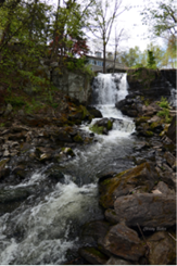
Description: Aspetuck Falls, a.k.a. New Preston Falls, is a 20-foot-high waterfall formed on the East Aspetuck River—a medium size stream which rises from Lake Waramaug at an elevation of 694 feet, and joins with the West Aspetuck River south of Wellsville before flowing into the Housatonic River at New Milford.
Old foundations are visible along the east bank at the base of the fall, possibly the ruins of a stone sawmill once used for cutting slabs of rock for monuments.
History: At one time New Preston was a viable industrial center, using the power of the East Aspetuck River to run a tannery, forge, twine & cotton factory, a cider-brandy distillery, and carpentry shop. Originally the village was known as New Purchase, but an early settler named Edward Cogswell changed the name to New Preston in honor of his home-town village of Preston in east Connecticut.
Lake Waramaug is located directly north of New Preston, and is the state’s second largest natural body of water. The East Aspetuck River, rising from this lake, passes through Tinker Hill Gorge, a.k.a. Marks Hollow, where multiple dams intercept the river before it reaches New Preston and Aspetuck Falls. Lake Waramaug’s name comes from a Native American who was chief of the Wyantenock tribe.
Aspetuck is a Paugussett word for “height,” “high places,” or “fish net place,” the former two presumably referring to the surrounding hillsides
Directions: From New Milford (junction of Rtes 202 & 67), drive northeast on Rt. 202 for approximately 7.5 miles to New Preston (junction of Rtes 45 & 202). Turn left onto Rt. 45 (East Shore Road) and drive north for less than 0.1 mile to a small parking area on your left. Excellent views of the waterfall, just a short distance upstream, can be obtained from a stone platform overlook.
Dean’s Ravine Falls
Location: North of West Cornwall, Deans Ravine; Mohawk Trail
Estimated GPS: 41º55.10’N; 73º20.56’W
Views: Head-on and lateral
Aesthetics: Excellent
Characteristics: Scenic; remote; large
Accessibility: 0.3-mile hike
Degree of Difficulty: Moderate
Information: Trail map available in Connecticut Walk Book: The Guide to the Blue-Blazed Hiking Trails of Western Connecticut. Nineteenth Edition, page 211.
Description: Dean’s Ravine Falls, a.k.a. Reed Brook Falls, is a 50-foot-high cascade located in Dean’s Ravine and formed on Reed Brook—a small stream that rises south of Yelping Hill in Cream Hollow, and flows into the Housatonic River west of Hough Mountain. Several smaller cascades can be seen before the main waterfall is encountered.
History: Dean’s Ravine is a deep trench formed on the west shoulder of Music Mountain. The ravine has also been spelled Dean Ravine and Deane’s Ravine, a name possibly attributable to John Dean, an early settler, or one of his six children.
At one time seven dams impounded Reed Brook. The stream is named after Hawley and Harry Reed, two brothers who bought a farm in the hollow at the foot of Bunker Hill.
Directions: From Falls Village (junction of Rtes. 7 & 126), drives south on Rte. 7 for 1.5 miles and turn left onto Lime Rock Station Road.
From West Cornwall (junction of Rtes. 7 & 128), go north on Rte. 7 for 6.4 miles (or 0.3 mile past the junction of Rtes. 112 & 7), and turn right onto Lime Rock Station Road.
Coming from either direction follow Lime Rock Road south, taking note that the road becomes River Road along the way. At 1.0 mile, turn left onto Music Mountain Road and drive uphill, heading southeast. When you come to the intersection of Music Mountain Road and Cream Hill Road at 0.8 mile, turn quickly left into a parking area.
Proceeding on foot, follow the blue-blazed Barrack Mountain Trail from the parking area, immediately turning left when you come to the ravine. The path, now paralleling the ravine, will quickly take you down to the level of Reed Brook where a small cascade is visible upstream. Continue your walk downstream.
At 0.1 mile the ravine narrows markedly, compressing the stream. Several small cascades can be seen here. Looking downstream you will observe the brink of the main waterfall where Dean’s Ravine opens up and drops dramatically 50 feet into a lower section of the gorge.
Continue following the blue-blazed trail as it passes by the top of the main waterfall to your right. Although the trail initially seems to lead away from the waterfall, it quickly switches back, and descends to the bottom of the ravine where excellent views of the waterfall can be obtained.
If you follow the blue-blazed trail further downstream it will eventually intersect Music Mountain Road at a point downhill from where you parked.
To see additional falls on Reed Brook, return to the parking area and follow the blue-blazed trail upstream for 0.05 mile. The trail emerges onto Music Mountain Road. Walk over to the small bridge which spans Reed Brook. To your right is an 8-foot-high cascade; to your left, downstream, is a smaller cascade.
Hatch Brook Falls
Location: Northwest of Cornwall Bridge, Housatonic Meadows State Park
Estimated GPS: 41º49.99’N; 73º23.00’W
Views: Lateral from top of bank; head-on from streambed
Aesthetics: Good
Characteristics: Remote; scenic; medium size
Accessibility: 0.2-mile hike
Degree of Difficulty: Moderate
Information: Housatonic Meadows State Park, 159 Macedonia Brook Road, Kent, Connecticut 06757; (860) 927-3238 or Toll Free (866) 287-2757; Email: dep.stateparks@po.state.ct.us
Trail map available at ct.gov/dep/cwp/view.asp?a=2716&q=325220, and in the Connecticut Walk Book: The Guide to the Blue-Blazed Hiking Trails of Western Connecticut. Nineteenth Edition, page 34.
Description: Hatch Brook Falls is a 30-foot-high cascade formed on Hatch Brook—a small stream which rises in the hills northwest of Cornwall Bridge, and flows into the Housatonic River just east of Rte. 7. The waterfall is contained in a small gorge whose north wall is sloped sufficiently to enable a hiker to scramble down to the bottom of the ravine for a closer look. Hatch Brook Falls is best visited in early spring or following heavy rainfall due to its limited watershed.
The brook and falls are likely named either for the abundance of mayflies and caddis which hatch here in the early spring—beneficiaries of the water’s idyllic ph level that results from the streambed’s underlying limestone deposits—or after Captain Ebenezer Hatch who came to Sharon from Kent in 1768, and whose name has been given to a nearby pond where a puddling works once melted down pig iron to rid it of slag.
History: Hatch Brook Falls is located in the Housatonic Meadows State Park.
Cornwall Bridge was earlier known as Deantown after Dr. Reuben Dean who built the town’s first mill, named Red Mill, around 1750.
Like West Cornwall, Cornwall Bridge became heavily involved in smelting iron during the nineteenth century. The cumulative effect of this industry on the environment, however, was devastating. Forests were reduced to fields of rotting stumps as trees in increasing numbers were harvested to produce charcoal—a concentrated form of energy which generated the intense heat that the forges required. Once the forests were gone, the days of charcoal production were numbered.
Directions: From Cornwall Bridge (junction of Rtes. 7 & 4 West), drive northwest on Rte. 7 for over 1.0 miles. Pull into a parking area on your left just before crossing over Hatch Brook. You will see a sign next to the road that states “Blue Pine Knob Trail Loop.”
Approaching from West Cornwall (junction of Rtes. 7 & 128) drive south on Rte. 7 for 3.1 miles and turn right into a parking area.
The short hike follows a trail frequently used by hikers who set out on the 2.5-mile-long Pine Knob loop.
From the side of the parking area follow the blue-blazed trail north for several hundred feet. Rock hop over Hatch Brook via several large stepping stones, and turn left at the top of the ravine. Follow the trail uphill for 0.2 mile, paralleling Hatch Brook, which stays to your left. When you come to several mammoth boulders deeply embedded in the earth, turn left, and make your way down the side of the ravine and over to the base of the fall. Since there is no formal path, a short 50–75-foot scramble will be necessary.
If you wish, lateral views of the cascade can be obtained from the top of the ravine, roughly a hundred feet further uphill past the boulders.
In another 0.1 mile the blue-blazed trail descends to nearly the same level as the streambed where a 20-foot-long waterslide can be seen. It is not tilted vertically enough, however, to qualify as a cascade.
Additional Cascade: Pine Swamp Brook Falls (41º51.98’N; 73º22.18’W) is a 25-foot-high, two-tier waterfall formed on Pine Swamp Brook—a small stream which rises from east of Mine Mountain, and flows into the Housatonic River southwest of West Cornwall.
From West Cornwall (junction of Rtes. 7 & 128 East) go south on Rte. 7 for 0.5 mile. From west of Cornwall Bridge (junction of Rtes. 7 & 4 West), drive north on Rte. 7 for 3.6 miles.
Approaching from either direction, look for the waterfall tucked away in a narrow slot in the rock-wall along the west side of the road. The waterfall can only be glimpsed fleetingly from roadside, however, unless you park in a pull-off 100 feet from the fall and walk back carefully, hugging the guardrail and watching out for cars.
Kent Falls
Location: Northeast of North Kent, Kent Falls State Park
Estimated GPS: 41º46.57’N; 73º25.16’WFee: Modest charge on weekends and holidays from May through October. Out-of-state residents are charged a slightly larger fee.
Views: Head-on and lateral
Aesthetics: Excellent
Characteristics: Large; scenic; historic
Accessibility: 0.2-mile walk up trail to upper-most fall
Degree of Difficulty: Moderately easy to moderate depending upon the height of your ascent
Information: Kent Falls State Park c/o Macedonia Brook State Park, 159 Macedonia Brook Road, Kent, CT 06757; (860) 927-3238; stateparks.com/kent_falls.html;ct.gov/dep/cwp/view.asp?A=2716&Q=325228. [Kent Falls State Park website].
Trail map available at ct.gov/dep/cwp/view.asp?a=2716&q=325228
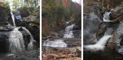
Description: Kent Falls consist of a series of impressive cascades and drops formed on Kent Falls Brook, a.k.a. Falls Brook—a medium size stream which rises in the hills east of Wyantenock State Forest, and flows into the Housatonic River a short distance downstream from the falls. Numerous pools and potholes can be seen in addition to the falls. The stream, which drains an area of six to seven square miles, descends over 250 feet in less than 0.2 mile.
Approaching the base of Kent Falls, visitors can see four separate cascades, the first two being formed in Stockbridge marble. At the base of the lowest fall is a shallow wading pool.
Additional cascades are encountered as you hike further upstream, culminating near the top with a 15-foot drop into a large pothole historically known as the “Maidens Well.” Just below it is a 20-foot-high cascade where the waters continue their downward course. The two together are frequently photographed by tourists. Look closely and you will notice that the image of a dog’s head is profiled in the rocks.
A number of potholes are prominently displayed in the bedrock near the waterfalls.
Several smaller waterfalls are contained further upstream near the confluence of Kent Falls Brook and a tributary of nearly equal size, but these are outside the park and on private land.
History: Kent Falls is considered by many to be the “jewel of the inland parks.” The waterfall is located in the 295-acre Kent Falls State Park which was created in 1919 through a gift of 200 acres of land from Alain White to the State of Connecticut. Since then additional parcels of land have been acquired.
Although little sign of past industrialization exists today, Kent Brook was populated by a variety of mills during colonial times.
In the 1930s, the Civil Works Administration set about to develop the area, assigning the work to Camp Macedonia Company #1191. Although the work was completed according to plan, by the 1970s the park was already in need of a serious upgrade, and the Youth Conservation Corp of Connecticut took on the project of revitalizing the park.
Despite all of this, in 2006 still more renovations were needed, and an additional $1.1 million dollars was approved. New viewing platforms were created, the trail was redesigned, and a terraced observation area was made out of native flag stone next to the wading pool at the bottom of the falls.
Kent Falls achieved minor celebrity status when it served as background for a show on TV’s long-running soap opera, the Guiding Light.
The 37-foot-long Town Lattice Truss covered bridge crossing Kent Falls Brook at the beginning of the trail was built in 1974 by Edmund Palmer, a park employee.
A reproduction of a painting of Kent Falls by Willard Metcalf, a well-known nineteenth century American Impressionist, is displayed on an on-site historic plaque.
Directions: From Cornwall Bridge (junction of Rtes. 7 & 4 East) drive southwest on Rte. 7 for 3.9 miles. Turn left into Kent Falls State Park.
From Kent (junction of Rtes. 7 & 341), drive northeast on Rte. 7 for 5.0 miles and turn right into the park.
From the north end of the parking area, follow the main trail over a covered footbridge, and then across an open field to the base of the lower-most falls. From here, it is an ascent of over 250 feet following a well-constructed, in-laid stone trail, with periodic platform overlooks, and a railing made of thin cable that is neither obtrusive nor unduly offensive.
Macedonia Gorge & Falls
Location: North of Macedonia, Macedonia Brook State Park, Kent
Estimated GPS: 41º45.21’N; 73º29.58’W
Fee: None for visiting the waterfall; campsite fee only
Hours: Campsites are open from mid-April to September 30th. 51 sites available
Views: Lateral and head-on
Aesthetics: Fair
Characteristics: Rural; historic; small
Accessibility: Visible from top of ravine, or by following a short trail that leads down to old mill ruins
Degree of Difficulty: Moderately easy
Information: Macedonia Brook State Park, 159 Macedonia Brook Road, Kent, CT 06757; (860) 927-3238
Trail map available at ct.gov/dep/cwp/view.asp?a=2716&q=325234
Description: The falls in Macedonia Gorge are formed on Macedonia Brook—a comparatively small stream which rises in the West Woods areas, and flows into the Housatonic River by Kent.
The falls consist of a series of small cascades, none greater than 3–4 feet in height, which extend through a 100-foot-long ravine where the bedding is noticeably tilted. The stone ruins of an old forge can be seen by the base of the lower-most cascade where a small pool of water has formed. Flakes of iron ore are noticeable along the path that leads downhill to the ruins.
A small cascade 0.4 mile further upstream can also be seen. Like the ones in Macedonia Gorge, this fall is relatively unobtrusive. It is located on the left side of the road in a fairly scenic area where picnic tables overlook the ravine.
History: The falls in Macedonia Gorge are located at Macedonia Brook State Park, a 2,294-acre preserve containing 13 miles of trails. The park’s main stream, Macedonia Brook, has also been known as Nodine Hollow Brook and Forge Brook in the past.
Macedonia Brook State Park’s history dates back to 1918 when 1,552 acres of land were gifted to the State of Connecticut by the White Memorial Foundation of Litchfield. During the 1930s the Civilian Conservation Corp (CCC) became heavily involved in shaping the way the park looks today.
The name Macedonia comes from the biblical Book of Acts where the Lord is asked to “Come into Macedonia and help us.”
The area near Macedonia Gorge was originally occupied by the Scatacooks (Schaghticokes), a Native American tribe whose name refers to the confluence of the Housatonic River and nearby Ten Mile River.
The nearby village of Kent was settled in 1738. Macedonia quickly followed and soon was bustling with shops that included a cider mill, sawmill, and gristmill. But it was for its foundries that Macedonia was best known, starting between 1770 and 1773, when an iron works was erected on Macedonia Brook.
In 1826 the blast furnaces at Macedonia began smelting iron ore to convert cast iron into malleable iron, producing crowbars, agricultural implements, wagon wheel rims, and other metal-based items.
By 1848 all the timber in the immediate area had been harvested, forcing the iron companies to import timber from ever expanding distances. It was undoubtedly the loss of easily obtained local timber and the resulting need to harvest large quantities from widening distances which led to the furnaces closing in 1865; this along with the stiff business competition from the larger Pennsylvania mines.
Today you can still see the remains of the forge and stamping works at the south end of the park.
Directions: From Kent (junction of Rtes. 7 & 341), head northwest on Rte. 341 (which starts off as Bridge Street) for 1.8 miles until you come to a sign for Macedonia State Park. Turn right onto Macedonia Brook Road and drive north for 1.0 mile. You will see, to your left, a kiosk where the park’s rules & regulations are posted. Park at a sizable pull-off to your right. From here a series of small cascades can be seen from the top of the ravine. For a better look, follow a short trail down into the gorge for upstream views of the cascades.
A second, solitary cascade is reached at 1.4 miles. You will see it down in the ravine on the left side of the road.
Although Macedonia Brook Road and, further uphill, Keeler Road can be followed north for roughly 4 miles, there are no further cascades. Still this is a wonderful camping area, particularly if you are interested in doing a variety of hikes, or summiting 1,380–foot–high Cobble Mountain.
The ranger’s cabin/park office is reached at 1.9 miles as you proceed into Macedonia Brook State Park.
Sages Ravine
by Rick Sowash
Four Places on the Appalachian Trail for violin, French horn, cello and piano (1992)
I. Amicalola – Allegro
II. Dragon’s Tooth – Allegro energico
III. Sage’s Ravine – Larghetto
IV. Katahdin – Molto allegro
Although it can stand alone, Sages Ravine is the third movement of a much larger work entitled Four Places on the Appalachian Trail. Here is what Rick had to say about the part for Sages Ravine:
“In this suite, I have tried to create musical gestures to convey feelings I have about four specific sites on the trail. The four movements — entitled Amicalola, Dragon’s Tooth, Sages Ravine, and Katahdin— are named after four of the trail’s outstanding features.
I like to think of Sages Ravine as a place where sages might be encountered, New England sages like Emerson and Thoreau, as well as present-day sages. What makes a sage? A sage reconciles opposites: joy and sorrow, good and evil, the sacred and the profane. They perceive the larger whole.
This piece begins with a musical evocation of Sorrow. After a while, the music of Joy is heard and in 9/8, the meter of Bach’s famous “Jesu, Joy of Man’s Desiring.” My music in this section actually blends that Bach tune with our American folksong, “Shenandoah.” Sorrow returns, joy returns, and by the end of the piece the two opposites are reconciled. Sagacity is achieved!”
To hear Sages Ravine, beautifully performed by violinist Cheryl Trace, French hornist Robert Garcia, cellist Robert Clemens and pianist Greg Kostraba, click here.

To see a PDF of the score by Rick Sowash, click here.
The piece is featured on the CD Vistas: Music Celebrating American Landscapes and it is available for purchase at the store on Rick Sowash’s website: www.sowash.com
Classical composer Rick Sowash is from Cincinnati, Ohio. Rick and his wife have been house-sitting/pet-sitting for vacationing residents of Litchfield County for the past seven years. During their visits to the area, Rick sings in the Cornwall UCC choir and finds time to compose, when he is not bicycling. Check out his wildly popular book, The Moderately Lazy Biker’s Guide to Litchfield County and READ an article we wrote about Rick last year. Contact: rick@sowash.com, www.sowash.com
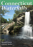
Connecticut Waterfalls, A Guide is available at local bookstores and through Amazon. It is also available as a Kindle e‑book on Amazon.
Russell Dunn is a New York State-licensed hiking guide and author of Connecticut Waterfalls, A Guide, and five other waterfall guides to the nearby Berkshire, Adirondack, Catskill, and Hudson Valley regions, as well as numerous hiking and kayaking guides. He and his wife, Barbara, live in Albany, New York.
Christy Butler is a photographer. His photographs of waterfalls are published in Connecticut Waterfalls, A Guide, and he has published several posters of his waterfall images.
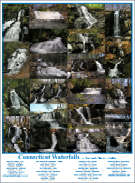
His posters are available for $10 at: www.berkshirephotos.com
For more information: chrisjan@berkshirephotos.com
Christy is also the creator of www.shoeboxphotos.net, which restores and displays photos taken by military veterans to provide a personal insight into the military experience. He and his wife, Jan, live in Cheshire, Massachusetts.
For 360° panorama images of waterfalls throughout New England, go to: www.berkshirephotos.com
Follow the link to the waterfall index page and scroll down to Connecticut.